|
Southeastern Spitsbergen landscape-seascape and biodiversity dynamics |
|||||||||||||||||||||||||
|
|
|||||||||||||||||||||||||
 |
|||||||||||||||||||||||||
 |
|||||||||||||||||||||||||
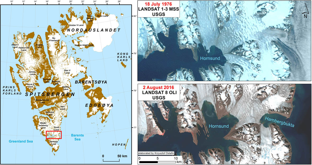
The study area consists of the glacial isthmus between Sørkapp Land and the rest of Spitsbergen, and the adjacent southeastern Spitsbergen coast ca. 30 km long. It is an extremely interesting area from a geographical point of view due to a dramatic transformation of its environment and landscape since the beginning of the 20th century, i.e. after the Little Ice Age.
|
|||||||||||||||||||||||||
 |
|||||||||||||||||||||||||
|
The map of Spitsbergen (on left) was elaborated based on map from Norwegian Polar Institute (2014). Kartdata Svalbard 1:100 000 (S100 Kartdata). Norwegian Polar Institute https://data.npolar.no/dataset/645336c7-adfe-4d5a-978d-9426fe788ee3 |
|||||||||||||||||||||||||
The glacial isthmus has been narrowed from 28 km in 1899-1900 to 5.6 km in 2016 and lowered by 60-200 m during this period. Two isthmus' glaciers will have melted, given the current temperature conditions, by 2030-2035 (Ziaja & Ostafin 2015). Hence, Sørkapp Land will become a new big island separated by a new strait (which will origin due a to final connection of the Hornsund and Hambergbukta fjords which are being more and more longer) because the glaciers' bottom is below the sea level.
|
|||||||||||||||||||||||||
|
The project benefits from the support of the Prince Albert II of Monaco Foundation www.fpa2.com This document was produced with the financial assistance of the Prince Albert II of Monaco Foundation. The contents of this document are the sole responsibility of Jagiellonian University in Krakow and can under no circumstances be regarded as reflecting the position of the Prince Albert II of Monaco Foundation |
|||||||||||||||||||||||||
|
|||||||||||||||||||||||||